


Snow day!
Our storm is here ❄️

Subscribe and join our community for insider updates and analysis. Weather is more than just a daily report—it's a story!
Snowfall forecast
Winter storm warnings and advisories posted

Discussion
📝 Storm Summary: A developing low pressure system will intensify this afternoon, tracking south and east of the region. This trajectory will result in colder, snowier conditions, particularly near and south of the I-95 corridor. Winter Storm Warnings and Winter Weather Advisories have been issued for parts of Pennsylvania, New Jersey, Maryland, and Connecticut due to expected significant snowfall.
⏰ Timing: Precipitation starts late morning to early afternoon, moving from southwest to northeast. The heaviest precipitation is expected between 4 PM and 9 PM, with snow rates possibly exceeding 1 inch per hour. Snow will start tapering off from southwest to northeast into the overnight hours, with most accumulation ending by midnight.
🌨️🌧️ Precipitation Types: Initially, there might be light rain or a rain/snow mix near the I-95 corridor, with mainly snow further north and rain further south.❄️ As the low pressure moves off the coast, colder air will lock in, converting any mixed precipitation to snow, particularly in the afternoon and evening.
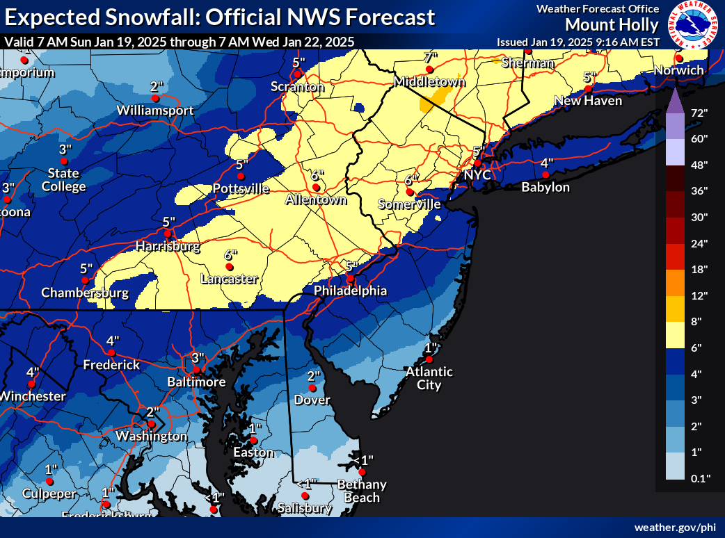
Snowfall Totals:
Near I-95 corridor: 4 to 6 inches. ❄️❄️❄️❄️
North of I-95: 6 to 9 inches. ❄️❄️❄️❄️❄️❄️
South of I-95 corridor: 2 to 4 inches, decreasing to 1 to 2 inches or less in the southernmost areas from central Delmarva to Atlantic City, NJ. ❄️❄️
Warning areas (including parts of PA, NJ, CT): 6-8 inches. ❄️❄️❄️❄️❄️
NYC metro: 4-6 inches. ❄️❄️❄️❄️
Long Island and coastal CT: 3-5 inches, with potential for up to 6 inches in advisory areas if conditions align. ❄️❄️❄️
Conclusion: The storm will bring a significant amount of snow, transitioning from mixed precipitation to predominantly snow as the day progresses. Following the snowfall, very cold and blustery conditions are expected, with wind chills in the single digits or below, leading to potential for blowing snow and icy conditions into Monday. 🌬️🥶
About us
I’m a weather enthusiast passionate about providing weather reports and engaging discussions for New Jersey and its surrounding areas. My fascination with weather has been a lifelong journey, and I continue to find joy in following forecasts and creating my own. Although I didn’t complete a degree in Meteorology, my experience and dedication to the subject matter have honed my ability to provide accurate forecasts and facilitate weather discussions for the tri-state area.
Weather is a constantly evolving and dynamic force that captivates my attention. I strive to provide the best possible forecasts based on my knowledge and avoid exaggerating or misleading information about the weather conditions outside. I hope you all enjoy this page and share my enthusiasm for the weather around us. Feel free to reach out with any questions or comments. Thank you for your support!